|
Cause and Opportunity
Are you one of Forbes' +/- thousand, spring-published billionaires who might be interested in an exceptional do-good-charitable-altrustic-benevolent ecological development that is world class unique while a self sustaining cash cow, that will create your enduring living legacy to leave behind for applauding and appreciative future generations?
An inimitable wildlife and botanical Mother Nature’s wonderland to compete with the world’s best like the Serengeti of East Africa and much more. That is the Mozambique Elephant Coast-Wildlife-and-Botanical National Park development at 4000 Sq Mi with a fifty mile stretch of breath taking, rugged, pristine Indian Ocean high-dune-forested coastline, the Maputo River, 40 lakes (most with hippos and flamingos, some with crocodiles)—sound too good to be true? Then you should take a look at what is probably our world’s best such exquisite green CAUSE and altruistic cash cow OPPORTUNITY. That is In partnership with the land owner, the Government of Mozambique (GoM), with the bush natives as development partners, the rescued endangered African wildlife and the whole ecosystem protected under the UN’s International Biodiversity Accord. That is to financially support the resurrection of an expanded 4000 Sq Mi MOZAMBIQUE ELEPHANT COAST development project to RECREATE MOTHER NATURE’S WILDLIFE WONDERLAND AFRICA. Partner GoM puts in the land at no cost, retains 10% of your development’s equity shares. You get an international class engineer-manager to develop it—while keeping it native and unspoiled as per UN mandate, and you get an operational partner; Disney, Sun Hotels, ConsCorp, Four Season Hotels to manage its operation. The plan entails auctioning off wildlife watching safari and other tourist concessions al la Mala Mala, Londolozi, Singita, Phinda (the project's MLSP paradigm class cash cow successes all operating within 100 miles of the Elephant Coast site) as featured in Travel+Leisure magazine’s World’s Best tourist destinations list-competition in most recent years, at the top of the list.
The development is accessed by an antique steam train, while wildlife experts have trans-located in thousands of endangered African wildlife (saving them from a death sentence like 5000 nearby Kruger National Park elephants currently face), a transitional stage to establishing the Elephant Coast development as a permanent enduring National Park in Mozambique, like Africa’s Serengeti or America’s Yellowstone National Parks. This would be the first time in world history for private enterprise to establish a National Park vs. it being done by a National Governments, in America, Africa or else where. Or one can say establishing such a permanent National Park (in this case to-be) is something that usually only kings, potentates or National Governments can or have done. A bell ringer, this saves the Maputaland Center of Plant Diversity (CPD), UN mandated to be kept NATIVE and UNSPOILED under the International Biodiversity Accord as signed by the World’s heads of state at the Rio 1992 first Earth Summit which dictates the Elephant Coast’s development plan and philosophy which is 100% in accord with the UN CPD safeguards and goals, protecting the ecosystem in a way that would permit Mother Nature a rare smile vs. mankind’s more normal despoiling modern development. As Bernard Grzimec stated in his book Serengeti Shall Not Die (1959)—he who is largely credited with keeping that inimitable world class ecosystem intact native and unspoiled “Must everything be turned into deserts, farmlands, big cities, native settlements and dry bush? One small part of the continent at least should retain its original splendor so black and white men who will follow us will be able to see it in it awe-filled past glory”.
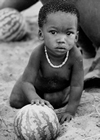
The diamond-in-the-rough Elephant Coast region is a very good candidate to be the world's next `saved’ Serengeti. And for the Elephant Coast development the local bush natives (born and raised on the development's bush land) are not trans-located elsewhere, dumped, but rather taken in as preferred income shareholders—stakeholders in the development, to receive now none existent schools, medical facilities—including aggressive anti AIDS-malaria programs—work, improved situations and livelihoods in a transition from their current near stone age starvation condition to healthy, happy, uplifted lifestyles—manna from heaven, while being the source of needed development manpower. And how is it a cash cow? By partnering the land, indigenous land residents, and wildlife in an ecotourism development triad which attracts international wildlife-watching tourist, funds and fuels the then henceforth self sufficient-altruistic-charitable-benevolent cash cow development, a tight synergy. Two more bell ringers, the 4000 Sq Mi version ties into the Great Limpopo Transfrontier Park (GLTP) to the immediate north, amalgamations of adjacent no-internal-fence wildlife refuges of existing National Parks in South Africa, Zimbabwe and an expanding mirror image one in Mozambique which already has boundaries set at 38,500 Sq Mi, thus is the largest such no-internal-fence wildlife refuge in the world by a factor of almost two. (See book’s Exhibit E-GLTP for map and more details so it tells its story). The other bell ringer, a small percentage of the 1996 development, at the very north, Inhaca Island and the Peninsula, two percent of the development acreage and the sheltered inner Maputo Bay to the west is dedicated to beach and water sports, including scuba and deep sea fishing. In Africa wildlife tourism is number one, beach and sea activities are the number two tourist draws. This development thus would offer both in world-class-level spades. SEE THE WHOLE OF THIS ALTRUISTIC-CHARITABLE-BENEVOLENT CASH COW DEVELOPMENT IN THE BOOK TITLED SAVE MOZAMBIQUE’S ELEPHANT COAST.
But this inimitable corner of our earth has to be dedicated to such a plan NOW, before God and Mother Nature’s bountiful gifts to mankind are despoiled by other normal down market commercial and materialistic activities in economically struggling post civil war Mozambique. That is despite the whole of the 4000 Sq Mi proposed development area being earmarked or mandated to be safeguarded native and unspoiled by the UN’s International Biodiversity Accord (1992 Rio Earth Summit) as the Maputaland CPD.
See below the 914 Sq Mi 1995-1999 Exhibit A (book pages 45-47) version of the Elephant Coast that failed to be built out when the American entrepreneur (pseudo developer) threw craps, a bait-then-switch, and failed to perform and build out the development.
|
The BOOK'S EXHIBIT A ELEPHANT COAST 1996 - This first sketch map locates the 914 Sq Mile Elephant Coast Development
The 1996 development’s north end location in relation to Maputo is due east to Inhaca. Then the Machangulo Peninsula extends to the south, widening out to the Maputo River to the south, the wildlife watching safari, MLSP paradigm ecotourism concessions area to the South African border.
The project started with the Peninsula only being offered by GoM, which was not viable. This was resolved by adding a land corridor across Inhaca, with sheltered deep water access on Inhaca Island’s west coast then a ten kilometer long rail corridor across the Island south east to Cape Torres, then a bridge to the Peninsula’s north end, Cape Santa Maria. The plan calls for some other development on Inhaca, a hotel and golf course on the south west peninsula of Inhaca Island, and other use of its west coast for such activities as the deep sea fishing, scuba and Club Med or Sandals installation(s). That is water sports activities, as the main Indian Ocean coast is a storm beach, with no beach exposed at high tide. Thus the developments water sports activities are planned for Inhaca’s west coast, or on man made islands west of the Machangulo Peninsula, several kilometers west at the drop off to deeper Maputo Bay water.
But an astronomical change was adding on of the huge area to the south of the Peninsula, including the shot out Maputo Elephant Reserve, then south to the KwaZulu Natal, South African border, and west to the east bank of the Maputo River. Everything south of the Peninsula is dedicated to the top rung world class MLSP paradigm of wildlife viewing ecotourism. Thus to be viable the development went thru a sow’s ear 40,000 acre to silk purse 585,000 acre transition which resulted in the then 914 Sq Mi 1996 project version, adding a proven tourist draw with MLSP safari lodge concessions. The overall development became viable with Inhaca Island and the Peninsula as the land bridges of how you got there, to Mother Nature’s big southern wildlife show—with some alternate access to the south by water up the Maputo River. The expansion south started as only the revitalization of the shot out Maputo Elephant Reserve, but ended up some three times that size, by being extended to the South African border and west to the east bank of the Maputo River. The now viable project was so approved by GoM in late 1966. For scale, Maputo due east to Inhaca village is eighteen miles or thirty kilometers. A prominent feature is the east boundary of the project, fifty miles or eighty kilometers of Indian Ocean starkly beautiful high forest dune coastline from Cape Santa Maria to the South Africa border.
 The development’s boundary then runs west along the South African border for fifty kilometers or thirty miles to the east bank of the Maputo River, which is the 1996 Elephant Coast ‘s west boundary north to the river’s mouth on the Indian Ocean’s Maputo Bay. Then it is the Maputo Bay shoreline east to the Peninsula, north with the Peninsula then Inhaca’s west coast the limits. Except there are plans to use the shallow inner bay west of the Peninsula for man-made-islands, possibly a major air facility in the shallows vs. disturbing Mother Nature’s CPD botanical garden on land for such a large structure. The development’s boundary then runs west along the South African border for fifty kilometers or thirty miles to the east bank of the Maputo River, which is the 1996 Elephant Coast ‘s west boundary north to the river’s mouth on the Indian Ocean’s Maputo Bay. Then it is the Maputo Bay shoreline east to the Peninsula, north with the Peninsula then Inhaca’s west coast the limits. Except there are plans to use the shallow inner bay west of the Peninsula for man-made-islands, possibly a major air facility in the shallows vs. disturbing Mother Nature’s CPD botanical garden on land for such a large structure.
Click on image of map to enlarge.
Locations discussed in the narrative, Catembe (ferry), Bela Vista, end of existing rail spur, rock quarry; Salamanga where one crosses by bridge to the east side of the Maputo. Note Ndumo Game Reserve and Tembe Elephant National Park in South Africa that play into the Trans Frontier Conservation Area (TFCA) discussions to the south west, with their north borders with Mozambique, thus the Elephant Coast. The Machangulo Express rail system is not shown, as its routing is not yet set. But it would start near the Inhaca village, then cross Inhaca west to east; south down the Peninsula then most probably split the large southern wildlife-watching MLSP area east and west of the rail into safari lodge concessions on its coast-side, then a tier of Maputo River side concessions from the middle, with the external rail from Bela Vista tying into the development’s international rail system from the west.
|
The 4000 Sq Mi Elephant Coast development will connect up to the Great Limpopoo Transfrontier Park, the world's largest wildlife refuge by a factor of two at 38,500 Sq Mi.
See an eight minute video fly over of the inimitable rolling game viewing vistas between the starkly beautiful Indian Ocean coastline and the Maputo River from Inhaca to the South African border, with forty some lakes, the 914 Sq Mi (1996) heart of the to be expanded to 4000 Sq Mi development. (The 27 minute video is available to view from the video link). See the Great Limpopo Transfrontier Park to which the Elephant Coast would land-bridge connect up with to it's north.
|
BOOK'S EXHIBIT E-GREAT LIMPOPO TRANSFRONTIER PARK (GLTP)-This sketch map shows the three country amalgamation of National Parks in South Africa, Zimbabwe and Mozambique that when completed; expanded east into Mozambique will be 38,500 Sq Mi, the largest such internal free range wildlife refuge in the world, by a factor of approximately two. The GLTP is made up of South Africa’s Kruger National Park in the GLTP’s south west against the Mozambique border to its east, from the Limpopo River south to the N4 highway. Then in the GLTP’s northwest, against the Mozambique border between the Save River and the Limpopo is the Gonarezhou National Park in Zimbabwe. Then the newer mirror image Limpopo National Park in Mozambique is being created to the east from north of the Save River south across the Limpopo River to the N-4 highway. The plan is to eventually—ASAP—remove the international fences and let the wildlife have free range of the entire three nations GLTP.
Meanwhile this book proposes that the Elephant Coast be resurrected and expanded to 4000 Sq Mi to connect up with the GLTP from the south at or near the Maputo to N4 highway. This would allow wildlife in the south to range as far as to north of the Save River, including from Ndumo and Tembe wildlife refuges in KwaZulu Natal (South Africa), see Exhibit A. This would be a huge win-win for Mother Nature and civilized man’s current—and appropriate—attention to the other members of Noah’s Arc since the first National Park worldwide was created, Yellowstone in Wyoming in 1872, followed by Kruger National Park in 1898 with too little land dedicated to wildlife.
The question that Mozambique politicians have to address, is why not? Having dedicated as much Mozambique land to the Limpopo National Park, which has the world’s ecologist applauding, why not add a small amount more; the 4000 Sq Mi expanded Elephant Coast development. It is superior quality land for wildlife watching, has a connection to the Indian Ocean frontage. But more importantly, it is mandated to be kept native and unspoiled by the UN’s International Biodiversity Accord, as signed by the world’s heads of state at the 1992 Rio Earth Summit. And what better land use is there, than dedicating it to wildlife viewing ecotourism, a perpetual self funding cash cow (see Chapter 3), while thus safeguarding it native and unspoiled for future generation as mandated by the UN.
The GLTP includes in its expanded border the existing Mozambique National Parks Zinave (1) and Banhine (2) to form parts of GLTP’s east  border. That is four previously isolated wildlife refuges now make one significantly larger one for a major win for Mother Nature’s wildlife’s unrestricted movement and range. Thanks to the Peace Parks not-for-profit funding and its Trans Frontier Conservation Area initiative by South African Anton Rupert (died Jan 2006), may he RIP, his work well done. The recent creation of the GLTP has God and Mother Nature smiling down from above. border. That is four previously isolated wildlife refuges now make one significantly larger one for a major win for Mother Nature’s wildlife’s unrestricted movement and range. Thanks to the Peace Parks not-for-profit funding and its Trans Frontier Conservation Area initiative by South African Anton Rupert (died Jan 2006), may he RIP, his work well done. The recent creation of the GLTP has God and Mother Nature smiling down from above.
Click on image of map to enlarge.
|
What is the price tag? About what the 100 or so American owners of major league football, baseball, or basketball franchises each have invested but meanwhile in Mozambique with the land at no cost (the place), endangered African wildlife trans-located in from adjacent overstocked National Parks (the entertainment) and an international African wildlife watching boom and craze to support it (a cash cow). Tourism (predominately wildlife oriented)  passed South Africa’s former number one GDP earner gold mining bullion for the first time ever in 2005. The project's 1996 version was to bring in $800 million in static investment to Mozambique. The Developer’s total construction budget up to tourist opening in year five to six was $312 million. But due to internally raised funds, selling off lots, concessions to tourist sub-concessionaires his maximum draw down was indicated at $137 million at the end of year four, with this returned by year six and one half, then at $63 million per year free cash flow-profit from there forward. See Exhibit I to the right, or page 40 Exhibit I in book, which is estimate and developer’s construction cash outflow and return on capital graph. passed South Africa’s former number one GDP earner gold mining bullion for the first time ever in 2005. The project's 1996 version was to bring in $800 million in static investment to Mozambique. The Developer’s total construction budget up to tourist opening in year five to six was $312 million. But due to internally raised funds, selling off lots, concessions to tourist sub-concessionaires his maximum draw down was indicated at $137 million at the end of year four, with this returned by year six and one half, then at $63 million per year free cash flow-profit from there forward. See Exhibit I to the right, or page 40 Exhibit I in book, which is estimate and developer’s construction cash outflow and return on capital graph.
Click on image of financial exhibit to enlarge.
What is the development plans schedule? Four to six years are needed to install the wildlife and the essential keep it native-and-unspoiled tourist lodges and logistic infrastructure, for the wildlife and wildlife watching ecotourism development to accomodate tourists.
Is this a wild dream? No, the 914 Sq Mi version, heart of the 99 year land lease development concession was awarded by GoM to an American entrepreneur in 1996; who unfortunately was not qualified and failed to perform. But the basic plan is well established, environmentally approved, is still sound, can be easily expanded to the 4000 Sq Mi version to land-bridge connect up with the Great Limpopo Transfrontier Park to the immediate north, all within the limits of the UN designated Maputaland Center of Plant Diversity. That is safeguarding the UN CPD for posterity as mandated by the UN’s International Biodiversity Accord (Rio 1992 Earth Summit). The 1995 feasibility and development plan was by a top international team out of London with significant input on wildlife and ecotourism by top world South African wildlife and wildlife tourism experts.
Where is it? Southern Mozambique, with 50 Mi of pristine high-forested-dune Indian Ocean coastline, from Inhaca Island south (only 18 miles across Maputo Bay from Mozambique’s capital Maputo) and it extends south the exhilarating 50 miles to the South African (KwaZulu Natal) border. Then, west along the border 30 miles to the Maputo River, then north to the where the Maputo River’s flows into the Bay of Maputo. Then east and north along the Bay's coastline, the west coast of the Peninsula and Inhaca Island. As such it is an hour by air from Johannesburg or Durban the wildlife and beach hubs respectively of all southern Africa. The expanded 4000 Sq Mi version extends west to Swaziland, north to land-bridge connect up to the Great Limpopo Transfrontier Park to the north, all in the very heart of the African wildlife watching craze’s hub of Johannesburg. Even at 4000 Sq Mi the development is wholly within and safeguarding the UN designated Maputaland Center of Plant Diversity. Then on the inner Maputo Bay, west shores of Inhaca and the Peninsula there would be a beach and water sports enclave, and two hotels with golf courses, to augment the 93% (914 Sq Mi version) dedicated to top drawer private (project’s MLSP paradigm) wildlife watching ecotourism, giving the development action in southern Africa’s two big tourism draws, wildlife watching and sun-sea-beach activities (including the development's scuba and deep sea sport fishing). Then most probably GOM would allow some gambling to compete with South Africa's Sun City and adjacent Pilanesberg National Park as southern Africa’s now primary wildlife-gambling double header tourist drawing destination.
A part of the Elephant’s Coast development's heart (914 Sq Mi 1996 version) renovated the Maputo Elephant Reserve (173,000 acres) created by the Portuguese in 1932, but shot out by Marxist–Cubans from military helicopters—by the early 1980’s, with only 100 of the former herd of 600 Elephants surviving, rhinos and other game (except for a few lake dwelling hippos and crocodile) reduced to zero. The plan for the 914 Sq Mi version was to reintroduce 16,600 head of otherwise endangered African wildlife. The 4000 Sq Mi version would give a home to some four times that number—which could include 5000 elephants currently under death sentence for over producing and overcrowding in adjoining Kruger National Park (of the GLTP).
The Elephant Coast development project could save 5000 Kruger National Park elephants doomed to culling (killing) due to overstocking, resulting overgrazing, and ecosystem despoliation.
Currently the 5000 Kruger National Park elephants are scheduled for culling (killing) for overstocking, and the resulting overgrazing and ecosystem despoliation. The Elephant Coast development going ahead could give these doomed surplus elephants needed land, life, while being a windfall gift to Mozambique of some $25 million, the going cost of that many elephants bought at auction and translocated to new homes. That is to the applause of Mother Nature and all her nature loving advocates of which these elephants have many worldwide, bringing great international headlines and positive PR and support to the Mozambique Elephant Coast Wildlife and Botanical National Park development .
Over the years with elephant overpopulation and ecosystem deterioration, elephant culling was practiced in Kruger National Park the world’s second oldest National Park established in 1898 (second only to Yellowstone in 1872—four year before Custer’s last stand of America's then still wild west). Kruger is huge with 7523 Sq Mi, but eventually has reached, surpassed its finite—or limited elephant carrying capacity. It is a matter of historical record that some 14,562 elephants `had-to-be-eliminated’ (culled-killed) in Kruger between 1967 and 1995 (an average of 500 per year). Then in 1995 newly installed South Africa’s President Mandela forbad the practice of elephant culling to quiet the international uproar from ecologists, with threats to South Africa’s important wildlife tourism industry from animal lovers, environmentalists, etc. But with increases in elephant populations since, there is currently a very controversial and much debated international plan that proposes the elimination of 5000 elephants (See Google `Kruger National Park Elephant Cull’). Meanwhile in Portuguese days the 173,000 acre Maputo Elephant Reserve had some 600 elephants in its 270 Sq Mi, an average of 2.2 elephants per Sq Mi. Scientist studying past destructive elephant overpopulations in Kruger NP (South Africa), Chobe NP (Botswana), and Tsavo NP (Tanzania) have determined that an elephant density of more than about 2.5 elephants per Sq Mi is what historically has led to ecosystem devastation. So at 2.2 elephants per Sq Mi—Maputo Elephant Reserve in Portuguese days—the 5000 to be culled Kruger National Park elephants would fit in about 2270 Sq Mi of the proposed 4000 Sq Mi expanded Elephant Coast development if it was brought onto line NOW, as a reprieve from, or stay of their impending executions. Turn the elephants loose while the Elephant Coast region is being developed, let them walk to their salvation to the south rather than being killed in Kruger National Park as planned. Think of the international press and good will that would accrue to Mozambique and the billionaire or whoever that took on the development of the 4000 Sq Mi version of the Elephant Coast, on top of all the other altruistic-charitable-benevolent virtues of this Elephant Coast development project.
Safeguard more of the Maputaland Center of Plant Diversity—which fortuitously extends beyond the proposed 4000 Sq Mi Elephant Coast development.
In 1995 and 1996 in developing the feasibility plan for the then 914 Sq Mi version of the Elephant Coast development, our study team was originally unaware of the existence of the Maputaland Center of Plant Diversity (CPD) as the project went from 10,000 acres to 585,000 acres (914 Sq Mi). The Center Of Plant Diversity concept was only introduced at the UN’s Rio 1992 Earth Summit as the goal and aspirations of the still-to-be International Biodiversity Accord signed by the worlds’ heads of state at that first Earth Summit. But in 1992 scientists were still sorting out what areas would be CPDs—that is the botanical equivalent of endangered species accreditation for mammals, birds, fish and reptiles, but in the botanical case rich and concentrated geographical areas rather than independent species was the approach. The three volumes of Centres of Plant Diversity were not published until 1994. They gazetted 250 areas worldwide, 84 in Africa chosen on their rich surviving mix of endemic plants as qualifying as UN CPDs—that is heavy in unique endemic botanical species not found elsewhere in the world. In October 1995 Professor Braum van Wyk from Pretoria University first made our Elephant Coast project team, Mozambique and the world aware of the special nature of all the land that is proposed for the Elephant Coast development’s 4000 Sq Mi version, but even extends beyond that 4000 Sq Mi development limits, south into KwaZulu Natal, west into Swaziland, and north beyond what becomes N4 (in South Africa) the main highway north then west out of Maputo to Pretoria and Johannesburg. The UN’s International Biodiversity Accord mandated that when CPDs were announced around the world (1994 publishing of three volumes) the countries where CPDs were designated had pledged (by signing the International Biodiversity Accord) they would make every effort to safeguard their CPDs native-and-unspoiled. The Elephant Coast development and its plan does that in spades for Mozambique and humanity, by protecting the CPD with a wildlife ecotourism development to add to the allure, altruistic virtues of the Elephant Coast development undertaking.
Wildlife tourism beats out gold mining bullion as South Africa’s traditional top GDP producer in 2005.
When one talks of South Africa, it is Africa's largest economy, one thinks of gold mining, they traditionally being the world’s top producer of gold bullion, which has been South Africa’s leading contributor to the country’s GDP, that is until 2005. That is when tourism (mostly wildlife oriented) which has been gaining over East Africa as the number one African wildlife watching safari destination, surpassed gold as South Africa’s top GPD producer. The 4000 Sq Mi Elephant Coast development is within an hour by air from Johannesburg (or Durban) now overtaking Nairobi as the world’s number one African-wildlife-watching-tourist-destination hub. The international wildlife watching tourism market is well proven for Mozambique and the Elephant Coast to capitalize on by their surrounding regional neighborhood's experience. That is the Elephant Coast with it superb CPD quality, wonderful rolling and undulating open game viewing vistas, starkly beautiful pristine Indian Ocean Coast, many lakes, Maputo River, sheltered Maputo Bay, is a potential favorite to become the top destination in all southern Africa. That is to say the world for African wildlife watching tourism, the fastest growing sector of international tourism, within the world’s biggest international industry, tourism. Again, the Elephant Coast development now is in the right place at the right time, world class.
Recreating Mother Nature's Wildlife Wonderland Africa
This is the subtitle of the book or the CAUSE, the plan and philosophy, the OPPORTUNITY to safeguard Mozambique’s Elephant Coast, its precious UN designated CPD, thousands of endangered African wildlife, and to uplift the struggling local residents and provide them positive aggressive AIDS-Malaria and other medical support, schools, employment for uplifted life styles.
This book’s Chapter two, pages 11 thru 27 (17 pages) is devoted to this subject—not so much the how to (elsewhere in the book)—rather providing a laundry list of the many exotic, inimitable virtues and attributes—the 'diamond-in-the-rough' of what you get—that makes this development target internationally high profile world class special. Then the long list of the developments idiosyncrasies; positive attributes tend to be synergistic, such that the whole ends up weighing in at much more than the sum of the individual parts. The bottom line overview is that the 4000 Sq Mi proposed development is all within the Maputaland Center of Plant Diversity, which Mozambique, and the world is obliged to try to keep NATIVE and UNSPOILED by the UN’s mandates of the International Biodiversity Accord as signed by the world’s heads of state at the Rio 1992 Earth Summit. The London development plan as approved by GoM in 1996 does that—fits to a T—by developing the region (up to 4000 Sq Mi) as primarily an international wildlife eco-tourism destination while the frosting on the cake bell ringer is the sun-sea-beach-water sports activities to the west in the inner bay of Inhaca Island and the Peninsula at the north end—which is the tourist's primary entry transit route to wildlife watching to the south. The main access to Inhaca is by water, then of transit within the development by antique steam train, from Inhaca south (or alternately all by water up the Maputo River for some safari lodge concessions to the west of the development).
The 1996 plan approved by GoM was 914 Sq Mi. It should have been extended to accommodate a strip on MLSP paradigm safari lodge concession on the west bank of the Maputo, and been approximately 1200 Sq Mi in 1996. This would constitute the heart of the development—Inhaca and Peninsula in the north, south to the South African border, from the Indian Ocean west to include the Maputo River (both banks). See Exhibit A narrative and map above. Expanding the development to 4000 Sq Mi would be fairly uncomplicated, as the essential infrastructure would be provided by the original 914 Sq Mi heart. The rest of the 4000 Sq Mi would be a corridor-land-bridge-wildlife-refuge connection with its west border up against Swaziland then the South African border to connect with the three nations’ amalgamated Great Limpopo Transfrontier Park (GLTP) to the north made up of Kruger National Park in South Africa, Gonarezhou National Park in Zimbabwe and the being established mirror image Limpopo National Park in Mozambique which encompasses already existing Mozambique National Parks Zinave and Banhine, see Exhibit E (GLTP) above.
Learjet Set Bedroom Community in an African Big Five Private Wildlife Preserve.
This private bedroom community is developed on the eastern two-thirds of the Peninsula with its surrounding private African big five (and other wildlife) refuge. This would be a world first to have residences, retirement homes, and time shares inside a Mother Nature’s African wildlife Eden. Some 350 to 400 private residence building sites are projected, clustered around the thirty lakes or with Indian Ocean views, co-habiting with freely roaming African wildlife, but especially the African big five, lion, leopard, rhino, Cape buffalo, and elephant. Then the Peninsula’s sheltered west coast mangrove swamp shoreline strip plus is isolated by an electrified elephant proof fence, thus reserved for the now African bush resident fisherman and their wives’ slash and burn garden plots and traditional shore- wading-and-boat fishing.
The African Big Five (et al)


The Others (et al)

Thus some 28,000 acres of the 40,000 acre Peninsula, all part of the UN’s Maputaland Center of Plant Diversity (CPD) is also dedicated to endangered African wildlife, which keeps it principally native-and-unspoiled as UN mandated, while raising funding (lot lease sales) to buy and translocated African wildlife in for both the Peninsula and the MLSP paradigm wildlife watching safari concession area to the south—93% of the 914 Sq Mi 1996 version of the Elephant Coast development. So what land uses make up the 914 Sq Mi development (see detailed laundry list walk through in book's pages 203 thru 207)? First, access is provided across Inhaca Island for the rail, giving access to deep water approach for tourist arriving from Maputo. West of the Peninsula is a non-navigable shallow sand bar out two miles or more. There are hotels with golf course's on both Inhaca and the north end of the Peninsula. Then the local Peninsula residents retain the west coast of the Peninsula protected by an elephant proof fence from the Jetsetters private wildlife refuge to the east. The Peninsula provides the routing for the rail access to the big south where wildlife watching safari concessions are the sole activity. Sun-sand-beach water sports—including scuba and deep sea fishing—are provided, but restricted to Inhaca, and west of the Peninsula (plus man made islands to the west) to add a beach tourist draw to the predominantly wildlife ecotourism Elephant Coast theme. The pristine Indian Ocean which is a storm beach, with no beach exposed at high tide, only being utilized for low tide foot traffic to preserve it's stark beauty as is.
Peninsula Images

Peninsula (l) Inhaca Island (r) Flamingoes abound Coastal 'Ponta' 
Resident Peninsula hippo's

Ponta and Lake Chemucane Inner Bay Coast

No 'beach highway' near high tide

Peninsula has 30 lakes. Cape Santa Maria looking east

On Inhaca, Peninsula seen south

Inhaca (l) Peninsula (r) Coast, Inhaca on horizon-high tide
Learjet-set bedroom community around Peninsula lakes 
Ponta and Lake Chemucane

High tide no beach

Ponta and Lake Chemucane looking south

Typical high forested dune Indian Ocean coast

Sheltered Peninsula inner Maputo Bay coast, high coastal dunes far horizon
MLSP Paradigm Private Safari Lodge Concessions
The MLSP paradigm is modeled after the nearby regional while internationally world class private-wildlife-watching-safari concessions, namely Mala Mala, Londolozi, Singita west of Kruger National Park, and Phinda south of the Elephant Coast in KwaZulu Natal. These four have been the leading international destinations in Travel+Leisure's World's Best annual survey of the top 100 'hotel' destinations around the world. How do these relatively small (less than 100 room, often less than half that) low profile, thatched roof safari lodges compete with (and beat) their multi-story glitzy competition worldwide? It's what's outside the lodges, the Mother Nature's daily wildlife show that puts them over the top. The 93% of the Elephant Coast acreage (585,000 acres) of the 914 Sq Mi or 1996 version was dedicated to this highly successful world class MLSP paradigm. The main draw being guests are assured a near 100% chance of seeing the African Big Five (lion, leopard, elephant, rhino and Cape buffalo) in a three night stay. That is with controlled low tourist density to insure good 'five-star' viewing and photo opportunities which results in the facilities commanding high bed night tariffs, most often being fully booked for up to a year ahead. This ensures the development plan's cash-cow element to fuel the wildlife watching ecotourism that saves the Maputaland CPD, re-established endangered African wildlife, while uplifting the poverty stricken bush residents within the development. See below the book's Exhibit C narrative and accompanying map showing the MLSP hot international tourist-destination locations nearby, the first three just west of Kruger National Park in South Africa, then Phinda in KwaZulu Natal just south of the Elephant Coast, with our proposed 4000 Sq Mi development sandwiched in between. The latest news; Travel+Leisure magazine's twelfth annual poll of the World's Best Awards (determined by readers) is out in their August 2007 issue. In the 100 Best Hotels (Destinations) worldwide, Singita (of our MLSP paradigm) was #2 in the world. Now in the most recent four years, Singita safari lodge (and game viewing concession) has been #1, #2, #1, now #2 again. Mala Mala and Londolozi have been the world's #1 in past years. Mala Mala was #21 worldwide in 2007. Five of the top 25 worldwide hotel destinations (20%) were African wildlife watching safari lodges which speaks well for the economic feasibility of the main theme of the Elephant Coast development. Londolozi in our MLSP came in #39 worldwide for 2007. In the Top 25 Hotels (destinations) of Africa and the Middle East, Singita was #1, fifteen of the twenty five were in southern or Eastern Africa with the sole pitch that of attracting wildlife-watching tourist. In the Top 15 Small Hotels worldwide (100 rooms or smaller) five, or a third were wildlife-watching safari lodges in Africa, so our MLSP paradigm is in an exclusive hot niche cash-cow industry.
|
EXHIBIT C: EXPANDED ELEPHANT COAST VIS-À-VIS MLSP-This sketch map shows the relationship of the Elephant Coast project's location (914 Sq Mi version) to the nearby MLSP sites as approved by GoM in 1996, then its proposed resurrection then expansion to 4000 Sq Mi to create a land bridge or corridor link up for free wildlife movement north to the three nation  international GLTP wildlife refuge. The expansion is first to a tier of MLSP safari concessions on the west bank of the Maputo River. Then a 'more-drive-through' wildlife refuge on the west to the Swaziland border, then north to the major road west from Maputo that becomes N4 in South Africa leading on to Pretoria or Johannesburg. North of the Maputo to Johannesburg N4 main road is the Great Limpopo Transfrontier Park (GLTP) with Kruger National Park in South Africa to the west and the being formed contiguous Limpopo National Park in Mozambique to the east, with its herein proposed link up by the 4000 Sq Mi Elephant Coast development from the south. international GLTP wildlife refuge. The expansion is first to a tier of MLSP safari concessions on the west bank of the Maputo River. Then a 'more-drive-through' wildlife refuge on the west to the Swaziland border, then north to the major road west from Maputo that becomes N4 in South Africa leading on to Pretoria or Johannesburg. North of the Maputo to Johannesburg N4 main road is the Great Limpopo Transfrontier Park (GLTP) with Kruger National Park in South Africa to the west and the being formed contiguous Limpopo National Park in Mozambique to the east, with its herein proposed link up by the 4000 Sq Mi Elephant Coast development from the south.
Click on image of map to enlarge.
There is a secondary road thru Swaziland from Maputo that links up with South Africa’s N2 highway in KwaZulu Natal south, eventually to Durban. Then there is N3 up over the Drakensburg Mountains back into Johannesburg. In Mozambique there is not currently another road south from Maputo to KwaZulu Natal that is feasible for less than a 4x4 all terrain vehicle, only the Maputo-Catembe ferry-Ponta do Ouro road (see Exhibit A above).
An important element of the Elephant Coast development plan is our chosen MLSP paradigm of private-wildlife-refuge-game-watching safari operations which the London study adopted as the model for the entire Elephant Coast territory south of the Machangulo Peninsula, i.e. private-refuge-wildlife-viewing-safari-lodge concessions. MLSP is our project acronym for the Mala Mala, Londolozi, and Singita west of Kruger, then Phinda south of the Elephant Coast paradigm. These are the world’s hottest African wildlife viewing destinations per Travel+Leisure magazine’s annual surveys; at least three of the four have won the Number One annual destination worldwide in recent years.
The take away message in this sketch, the Elephant Coast is in the red hot wildlife tourism’s MLSPs’ close vicinities sandwiched between these two MLSP regions (hearts on the sketch map) to the north west and south. The Elephant Coast development plan aims to come on stream with Mother Nature's richly endowed CPD quality raw land, with Indian Ocean frontage and ocean connection, to be one up on the existing world’s best MLSP sites, to challenge as the world’s number one game viewing destination. These four MLSP private refuges are the current class act of the booming international-wildlife-watching tourist industry, our development's adopted MLSP model after which over ninety percent of the total Elephant Coast acreage—everything south of the Machangulo Peninsula—is dedicated to, designed to emulate, an internationally market tested and highly successful model.
The proposed 4000 Sq Mi expanded Elephant Coast development being all within the boundaries of the UN’s Maputaland CPD, makes it more blessed by Mother Nature’s virtues and gives it a leg up on the current MLSP super stars, and the bigger but less endowed—non-UN CPD—GLTP wildlife refuge to the north.
GoM is to be praised for recently dedicating some 28,000 Sq Mi to the GLTP—their recently created Limpopo National Park—as a best land use, the region’s proven hot wildlife watching ecotourism. They now have a wonderful opportunity to add the 4000 Sq Mi Elephant Coast jewel, save the CPD, and open the wildlife tourist loop between the GLTP in the north and KwaZulu Natal’s wildlife refuges to the south, while going for the best land use, wildlife watching ecotourism a la MSLP paradigm.
|
Elephant Coast’s protected inner bay developed for sea, sun, and beach activities.
The fifty mile Indian Ocean coastline from Inhaca Island, twenty miles of the Machangulo Peninsula, then south to the South Africa border is a beautiful. pristine coastline featuring a stabilizing forested high dune structure, reportedly the world’s most prominent such high--dune-forested-stabilized-costal occurrence. But there is no exposed beach at high tide, as the Indian Ocean waves lap up to the steep main Indian Ocean bottom incline of the steep east facing shoreline dunes. The Elephant Coast development plan is to keep this coast as is, undeveloped, native-and-unspoiled, with no vehicle, only foot traffic (at lower tides).
Meanwhile the second biggest tourist pull to the region after wildlife watching ecotourism is salt-water-beach-sun activities. The Development is favored by a sheltered inner bay—protected by the high coastal dunes breaking the prevailing wind in off the Indian Ocean—west of the Peninsula and Inhaca Island. The Elephant Coast development plan is to have sea, sun, beach activities here which would include scuba, deep sea fishing, family holiday village island activities (like Club Med or Sandals) on Inhaca’s west coast or on sheet-pile-driven-dredge filled islands to the west of the Peninsula where the shallow shoal drops off to deeper water (3-4 Km west paralleling the Peninsula). These facilities would feature wind sailing, water skiing, snorkeling, etc. There would be a yacht harbor and marina west of Inhaca, a floating hotel (anchored luxury liner), Mississippi paddle wheel gambling boat to tour the bay and up the Maputo river, two hotels with golf courses, one on Inhaca, one on the northern Peninsula, all to take advantage of Mother’s Nature’s gift of this sheltered inner bay, to add frosting on the cake of the otherwise world class wildlife watching only theme. See the book's Chapter 17 for the scope of work of the development and more details. The map left shows the shallow shoal west of the Peninsula extending out to the outer limits of the sand shoal which is dry on the few lowest tides of the year—in robin egg blue. A string of man made islands at this outer limit would be quite feasible, to provide plenty of sun-sea-beach tourist concession activities to the development.


General Comment: The book SAVE MOZAMBIQUE'S ELEPHANT COAST about this CAUSE and OPPORTUNITY was written with Part I and Part II. The part that an investor (Gates-Buffett-Prince Alwaleed) would be interested in—the short and to the point now story is in Part I, chapters 1 thru 6. Meanwhile Part II (Chapter 7 thru 25 is essentially a chronological biography of the development projects evolution which has technical information sprinkled in, as the development plan unfolds, to the effect that the book is largely a 501 (C) (3) charitable operation tool, to educate the public and investors toward saving Mother Nature’s jewel, the Elephant Coast (4000 Sq Mi version) for future generations, as once gone it is gone forever.
The book makes access to the essential now information easy to obtain concentrated and summarized in the first seven chapters, and the concluding chapter 26 with the `how-to-contact-the-author' by buying the book, or an eBook for reference. That is access to the meat of the ongoing proposed 4000 Sq Mi development version as below, as:
1) Chapter 1-Prologue, condensed overview of the whole saga, pgs 1-6
2) Chapter 2-Mother Nature’s Wildlife Wonderland Africa-laundry list of the development’s natural and development plan virtues, pgs 11-27
3) Chapter 3-1998 Estimated Project Cost and Profitability, pgs 29-43
4) Chapter 4-Location Maps-Briefing, pgs 45-61
5) Chapter 5-Developer (Investor) Guide To Information-special index to technical sprinkle in Part II, so potential investor can find pertinent decision making information without having to wade thru near 300 pages of Part II by finding it's location Part II indexed in pages 63-68
6) Chapter 6-FAQs-about the Elephant Coast, 70-75. Elsewhere there is a current ongoing FAQ section where new and interesting answers to FAQ’s are posted as the occasion arises.
7) Chapter 26-Conclusion, pgs 361-62
|